Archive for the 'The Trip' Category

Wichita Falls, TX

I’m in Wichita Falls tonight. Apparently there is a rattlesnake problem – at a rest area on the way here, there were “Watch for rattlesnakes” signs all over, including one on the men’s room door. Probably the oddest juxtaposition is combining that with a “Pet area” sign:

Pet snakes?

In Wichita Falls, I dropped in at Eddie Hill’s Fun Cycles and photographed his award-winning car and boat:

Eddie Hill's Fun Cycles

I missed Eddie as I arrived late in the afternoon, but I exchanged some email with him and arranged to meet up tomorrow.

Amarillo, TX

Tonight I’m in Amarillo, TX – 430 miles or so from where I started today.

The weather was wonderful all day. A storm paced me around 2 miles to the south of I-40 around Wagon Wheel, NM but didn’t rain on me at all. Not too hot, not too cold – a perfect counter to yesterday.

My good deed for today was to help a driver explain what the problem was with his 18-wheeler to the repair service he called. I pulled into a rest area around 15 miles into Texas for a break, and rolled past the aforementioned 18-wheeler with its hood up and a huge cloud of steam drifting up into the air.

I walked back to it from where I parked and asked if I might have any tools or anything he needed. He said he didn’t know what was wrong, it just overheated all of a sudden.

I looked at it and discovered that the alternator had locked up (probably a bearing failure, as the shaft was out of line) and that it had thrown the main belt (crankshaft, alternator, fan, etc.) somewhere back along the road. He asked me if I had a lot of experience with these, and I replied “Nope, first time I’ve ever seen one”. I told him what to tell the repair people, and he called them back.

Part of the conversation went “Some guy in the strangest little car I’ve ever seen tells me that I need to tell you…”. After making sure that repair service was indeed coming out, I left him to wait for the repair truck and headed on down the road.

Footnote: I’m surprised at the number of people who don’t have any grasp of the fundamentals of engines. Maybe my surprise comes from growing up in a family that always had oddball imported cars – MG, Austin, Alfa, Fiat, etc. and being told I needed to rebuild an engine in a car before my Dad would put me on the family car insurance.

Gallup, NM

I’m in Gallup, New Mexico tonight. Today’s forecasts along the route were “scattered thunderstorms” along the route I was taking (I-40). What they didn’t mention was that they’d be over my head much of the way.

Not too far into Arizona, there was a brief thunderstorm which wasn’t bad at all – I got wet, and the breeze cooled down what was otherwise a hot day.

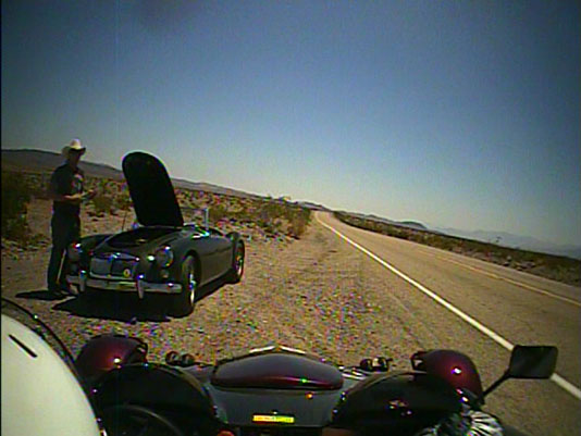
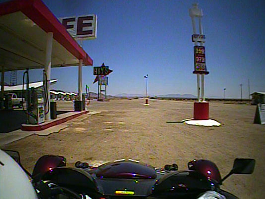
I stopped for gas and lunch in Flagstaff, AZ and not 15 miles out of town, the skies darkened and the weather looked very nasty up ahead:
Lightning up ahead

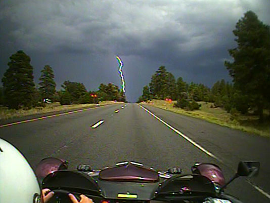
It got a lot worse very quickly:
Very wet indeed

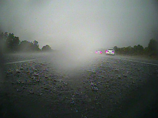
This is just before both of my cameras quit working. Maybe 2 miles past this, it got to the point where visibility was less than 50 feet. I took the next exit and took refuge under the canopy of a Shell station in Winona.

I left the Atom under the canopy and walked inside the station, still wearing my helmet, jacket, and driving gloves (all of which were soaked, like everything else I was wearing). There were a lot of people taking shelter in the station. Among others, we were joined by a highway patrolman and a sheriff. I had just completed the purchase of a roll of paper towels (to dry the inside of my helmet) and was wringing out my gloves over a garbage can when the power went out. Fortunately, the power came back in about 5 minutes or so. The station staff sent us all back to a normally-closed dining area (with formica furniture) to sit out the storm. I shared the paper towels with a pair of motorcyclists (a husband-and-wife team, I believe) who were also soaked through. Most of the other people just got somewhat wet when running from their enclosed cars into the station.

I struck up a conversation with one of the station employees, and said “Correct me if I’m wrong, but a) isn’t Meteor Crater about 25 miles from here, and b) in a desert?”

She replied that she’d called home (about 6 miles down the road) and it wasn’t raining there. The storm hovered over the station for about 45 minutes, with nearly no movement of the clouds in any direction. Eventually it died down to a drizzle and a bunch of us got going again.

It continued to rain on and off, but was warm enough that I could get mostly dry. By the time I got to Gallup, NM (my planned stopping place for the night – 400 miles from Needles, CA) it had just started raining heavily again.

I asked the manager of the hotel where the restaurants were, and she said “Get back on the interstate and go 4 miles to the next exit…”, and I replied that I didn’t want to risk that in an open car, given what I’d been through. She was very nice and took pity on me, and had me call in an order to a Chinese restaurant and then she drove down there to pick up the order and bring it back to me.

Depending on the weather, I may be stuck in Gallup again tomorrow – stay tuned.

Amboy and Needles, CA

I stopped at Needles in mid-afternoon – it is just too hot to keep going during the day, so I’m switching to night driving for a while. Of course, that means I’ll probably get rained on in the dark…

I left I-40 at Ludlow and headed onto Route 66:
Route 66 logo on road

About 10 miles down the road from Ludlow, I came upon a classic MG sitting on the side of the road with its hood up. My family had one of these in the 60’s, and it is a tradition to stop and swap war stories (and parts!) when you see one. I offered the driver some water and we chatted for a bit. His name was Jason and he was driving all of the still-existing parts of Route 66, starting in Chicago. You can’t make it out in the picture, but that’s a Chicago British Car Union badge on the car’s grille. He was just letting the car cool down, as cars of that era tend to run a bit hot (particularly when exported from the cooler British climate to the US):
Atom meets MG

After chatting a while, we both motored on down the road in our separate directions, and I arrived at Roy’s in Amboy. I was amazed to see that it was actually open and selling gas, soda, souvenirs and so on – all at very reasonable prices:
Pulling into Roy's in Amboy

The last time I came through (in 2004) the whole town had a “For Sale” sign on it:
Amboy for sale in 2004

I chatted with the folks running the store for a bit – apparently they’re planning on re-opening the motel / cabins in the future. The biggest issue seems to be that they don’t have any sort of septic / sewer system at the moment. While I was in there, nearly a dozen separate batches of visitors came in and went out – it is becoming quite a popular spot (well, for the middle of nowhere) again.

One parting picture and I was on the road again, heading East:
Atom at Roy's

Barstow, CA

I drove from Death Valley to Barstow today. With temperatures well over 100 forecast for the next few days, I’m not going to be able to make the distances I’d planned on each day.

Monday I’m going to drive through Amboy and try to get some pictures of the Atom at that famous sign.

After that, I may change course and head toward home via a more northerly route to try to get out of the heat. Rain is also forecast for parts of Arizona and New Mexico, so I may have to sit that out, too. I won’t need to make a final decision on changing my route until I get to Albuquerque, so stay tuned.

Death Valley, Day 2

This morning I headed out around 8:30 AM. I wanted to visit Ubehebe Crater, but by the time I got to Stovepipe Wells (about halfway) it was too hot for both me and the Atom. The Atom oil temperature hit 226 on some of the uphill pulls.

So I turned around at Stovepipe Wells and headed back to the Panamint Springs Resort where I’m staying. My room is a “comfortable” 97 degrees.

I’ll head out around 5 in the morning when the outside temperature should be down to the mid-90’s.

According to the National Weather Service, we’re having a heat wave:

Excessive Heat Warning
Statement as of 4:45 AM MDT on July 17, 2010

… Excessive heat warning remains in effect until 9 PM PDT /9 PM
MST/ Sunday…

The excessive heat warning covers elevations below 4000 feet for
Clark and southern Nye counties in southern Nevada… southern
Mohave County in Arizona… the deserts of San Bernardino County as
well as Death Valley National Park in eastern California.

* Expected temperature: 108 to 115 degrees in the Las Vegas
Valley… around 112 degrees at Pahrump and Barstow… 115 to 118
degrees from Mesquite south down the Colorado River valley to
Lake Havasu City… 122 to 125 degrees at furnace creek in Death
Valley National Park and 104 to 106 degrees at Kingman. In
addition… unusually high humidity will make it feel several
degrees hotter than it did Thursday with similar temperatures.

* Greatest impact areas: the hottest temperatures will occur
within the Colorado River valley and Death Valley National
Park. Plan any outdoor activities in the early morning or in
the evening after sunset.

Update: There were still temporary signs saying “Caution – runners on road”, as the Badwater Ultramarathon just wrapped up a couple of days ago. Out of 80 entrants, only 7 did not complete the 135-mile course. That is amazing!

Update 2: Here’s one picture from a run down the valley I did at sunset:
Atom in Panamint Valley

Update 3: After Panamint closed for the night, I gave the guy that was running the general store a ride down the valley and back after dark. He thought the Atom was a blast! There’s a very funny story about this ride – I asked the guy if he had a helmet, and he said “of course”. So, after he closed the general store he went back to his trailer to get it. After quite a while, he comes back and says “I couldn’t find it, but a friend gave me this thing as a gag gift. I’ll use that.” The “thing” in question was an old-style gas mask, with the accordion hose and canaster that hangs down like an elephant’s trunk. It is a good thing it was dark and the road was deserted – anyone seeing us would have died of laughter! The bright spot near the top left in the first video is the moon.

Now that a nice long time has passed, I’m making the following 2 videos public (they had been marked private before).

Rollbar camera video:

Nose camera video:

(The above videos are the full 480i versions. Click the Icon icon on the top right to go fullscreen.)

Death Valley National Park

I’m in Death Valley (at the Panamint Springs Resort) tonight and tomorrow night.

Let’s just say that driving here was intense – I must have gone through several gallons of water and a gallon of Gatorade. Today’s high here was 125 according to the park report.

Even outside the park, it was incredibly hot. At the point where the Path 65 DC transmission line crosses Highway 58, there was so much sag in the line from the heat that it looked like it was only about 50 feet above the road. Given that this line carries 3.1 gigawatts at 500KV, that’s pretty close.

The folks at Panamint Springs are still nice and friendly, as they were when they got the place just before I came through with the Atom in 2006 (before that, the place was run by seriously grumpy people).

Unfortunately, between 2006 and now they gave away The World’s Laziest Cat. I’m sure the cat likes it wherever it is now – it has to be cooler than here. Here’s a picture of TWLC from 2006:

The World's Laziest Cat

I’ll probably just hang out at the resort and do a few runs in the Atom tomorrow – it is too hot for extended drives (I’ll leave at night when it is cooler).

Sequoia, Day 2

I had two goals for today – to climb to the top of Moro Rock and to not be chased by a bear in Crescent Meadow. I had a 50% success rate:

Moro Rock: This large rock is one of the more prominent geological features in the park. As some of you may know, I have a very specific type of “fear of heights” – fear of losing my balance and falling. That’s because I do lose my balance easily – I’ve been known to look up to photograph a sequoia and fall over backwards. Anyway, in 2004 I made it about halfway up the rock before I chickened out and gave up. I set a goal for myself of making it to the top this time. Unfortunately, a combination of things – wearing driving shoes with slippery soles on loose sand on the rock, about 50 more pounds on me than in 2004, and the previously mentioned fear of heights led me to turn back about 75′ (vertical) from the top of the rock.

Not getting chased by a bear in Crescent Meadow: While this may sound like an odd goal, also in 2004, I was hiking on the High Sierra Trail in Crescent Meadow when I met a bear:

Bear in Crescent Meadow, 2004

(I tell people the bear was blurry because he was nervous).

Anyway, the goal today was to not meet another bear. I succeeded – no bears in sight.

I then decided to visit Crystal Cave. The second half of the road to the cave is not recommended for Atoms. After you get to the parking lot at the end of the road, there is a 1/2 mile hike down to the cave. Going down wasn’t bad – getting back to the top was, shall we say, “challenging”. They do have a sign that says “not recommended for people in poor physical condition”. I have discovered that I qualify.

After I got back to the parking area and drove back down the access road, it rained briefly. One of the things you notice in an Atom that you don’t get in a regular car is the scents. Sometimes (like when driving by a cattle feedlot) that’s not good. Other times (like Sequoia after the rain) it is fantastic. They should bottle that smell and sell it. The closest I’ve ever come to this smell back home is Cedar Pond, one of the mostly off-limit areas of the Clinton Reservoir watershed.

Pictures coming when I get a faster Internet connection.

Update – a whole bunch of pictures:

Near the top of Moro Rock:
Near the top of Moro Rock

That zigzag on the top is the road:
Road as seen from Moro Rock

The railing in the center of the picture is as far as I made it up the rock:
How far I got

The Forest Service was doing a “controlled burn” to clear debris on the ground. They had finished the area by Crescent Meadow, but the drive to there involved going through some pretty heavy smoke. By the way, this is the kind of picture where I fall over when taking it:
Looking up at tree

Here’s what the woods in the back of Crescent Meadow look like after the burn:
Burned trees

A hand-held shot of some of the formations in Crystal Cave. That’s my flashlight beam lighting up the center. I have some practice (scroll about halfway down the page) doing this:
Stalactites in Crystal Cave

Fat people need not apply (that’s me!):
People in Poor Physical Condition

Sequoia National Park

This park couldn’t be more different from Yosemite – the ranger at the gate was very friendly and just asked me if I wanted a map and newspaper (since I now have the annual pass on the car, they assume I might be a regular). He informed me of all of the road construction and when the best times to avoid delays were.

The road construction I encountered was very professionally managed, with one lane of paved road alternating directions every hour.

I feel sorry for the ranger that has to walk to all of the waiting cars and tell them when the road is re-opening. She had to walk a couple miles down the road (with the accompanying 1000+ feet of elevation change) and then back up. I told her they should get her a Segway. She has to do this 4 times a day.

I’m in the woods with a slow Internet connection – I may post some pictures later if it speeds up.

Update: Pictures, as promised…

A very lazy deer – it was walking along the paved path until I came along – then it went over the fence back into the woods:
Deer in General Grant Grove

The obligatory picture of the General Grant Tree:
General Grant Tree

My Atom overlooking Kings Canyon:
Atom at Kings Canyon

Yosemite, Day 2

I’m in Yosemite again today. Despite the stupidity with the roads (see the previous post), I managed to get some good driving done.

First, in Yosemite Valley:

Upper Yosemite Falls:
Upper Yosemite Falls

El Capitan:
El Capitan

I then drove up to Glacier Point and hiked to the Point from the parking lot:

Half Dome and Falls:
Half Dome and Falls

The Ahwahnee:
The Ahwahnee

This picture shows the hotel I’m staying at in Yosemite Valley. In the first one of yesterday’s 3 pictures from the hotel balcony you can see the view from the hotel looking up to this point.

Although the hotel and Glacier Point are only about a mile apart, the road snakes through the hills for 32 miles because of the elevation changes. Glacier Point is not the highest point on the road – that’s somewhere around Mono Meadow (I wonder if there’s a Stereo Meadow or a Surround Meadow). At the highest elevations there are still patches of snow in the shady areas along the side of the road.

Tomorrow I’m on to Sequoia / Kings Canyon which should be a lot less crowded.